オクシタニー地域圏
オクシタニー Occitanie | |
|---|---|
 オクシタニーの旗 | |
| 位置 | |
 | |
| 概要 | |
| 首府 | トゥールーズ Toulouse |
| 地域圏知事 | キャロル・デルガ |
| 人口 | 5,626,858人 (2012年) |
| 面積 | 72,724km² |
| 郡 | 36 |
| 小郡 | 269 |
| コミューン | 4565 |

2016年6月から2017年2月まで使用されたロゴ
オクシタニー(Occitanie)は、フランスの地域圏。
目次
1 名称
2 行政区画
3 姉妹自治体・提携自治体
3.1 提携自治体
4 脚注
5 関連項目
名称
かつてのラングドック=ルシヨン地域圏とミディ=ピレネー地域圏が統合されラングドック=ルシヨン=ミディ=ピレネー (Languedoc-Roussillon-Midi-Pyrénées)として、2016年1月1日に発足した。
ラングドック=ルシヨン=ミディ=ピレネーという名称は、地域圏の名称として今後使用されると意図されていなかった。この名称はアルファベット順にかつての地域圏の名称を並べたにすぎず、新しい名称が国務院のデクレによって選択されるまで法律上使用されることとなっていた。2016年7月1日をもって、統合後の新地域圏議会において可決された新名称が用いられることになっていた[1]。
2016年6月24日、地域圏議会は本会議において正式名称をオクシタニー(Occitanie)とすることの是非を問い、賛成で採択された。この名称を地域圏の公式発表で用いる際には、ピレネー=メディテラネ(Pyrénées-Méditerranée)のサインが添付される。コンセイユ・デタと政府の承認が完了してから、最終的な名称となる。
2016年9月28日、オクシタニーは公式名称となり、2016年9月30日より効力を持った。
行政区画
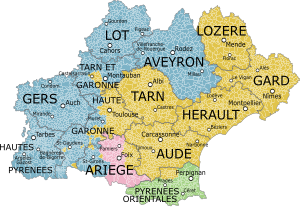
| 名称 | 人口(人) | 州都/主府/本部 | 備考 |
|---|---|---|---|
Hérault | 1,077,627 | モンペリエ Montpellier | |
Aude | 359,967 | カルカソンヌ Carcassonne | |
Gard | 725,618 | ニーム Nîmes | |
Lozère | 76,889 | マンド Mende | |
Pyrénées-Orientales | 457,793 | ペルピニャン Perpignan | |
Haute-Garonne | 1,279,349 | トゥールーズ Toulouse | |
Ariège | 152,366 | フォワ Foix | |
Aveyron | 276,229 | ロデズ Rodez | |
Gers | 188,893 | オーシュ Auch | |
Lot | 174,346 | カオール Cahors | |
Hautes-Pyrénées | 227,926 | タルブ Tarbes | |
Tarn | 381,872 | アルビ Albi | |
Tarn-et-Garonne | 246,971 | モントーバン Montauban |
姉妹自治体・提携自治体
提携自治体
 愛知県(日本国 中部地方)
2018年(平成30年)6月5日 相互協力提携[2]
脚注
^ « La carte des régions en 2015 », sur Vie Publique.
^ 「愛知県の海外との主な提携先
関連項目
- オクシタニア
| ||||||||


