ロヴィーゴ県
- ロヴィーゴ県
- Provincia di Rovigo
国
 イタリア
イタリア
州
 ヴェネト
ヴェネト
県都
ロヴィーゴ
面積
1,789.93 [1]km²
人口
- 総計
- 人口密度
2012-01-01
242,167 [2] 人
135.3 人/km²
コムーネ数
50 (50音順一覧)
主なコムーネ
アドリア、バディーア・ポレージネ、レンディナーラ、ポルト・トッレ、ポルト・ヴィーロ
略記号
RO
ISO 3166-2:IT
IT-RO
CAP
45100, 45019, 45026, 45010
市外局番
0425, 0426
ISTATコード
029
県公式ウェブサイト
[1]

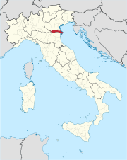
ロヴィーゴ県(イタリア語: Provincia di Rovigo)は、イタリア共和国ヴェネト州に属する県。県都はロヴィーゴ。
目次
1 地理
1.1 位置・広がり
1.2 地勢
1.3 県内の地域と主要な都市
2 行政区画
3 脚注
4 外部リンク
地理
位置・広がり
ヴェネト州の最南部に位置し、東はアドリア海に臨む。県都ロヴィーゴは東西に長い県域のほぼ中央部に位置し、フェラーラから北東へ約29km、パドヴァから南南西へ約38km、州都ヴェネツィアから西南へ約59km、ヴェローナから東南へ約75kmの距離にある。
隣接する県は以下の通り。
パドヴァ県 - 北
ヴェネツィア県 - 北東
フェラーラ県(エミリア=ロマーニャ州) - 南
マントヴァ県(ロンバルディア州) - 西
ヴェローナ県 - 北西
地勢
北のパドヴァ県との境はアディジェ川が流れ、西のマントヴァ県、南のフェラーラ県の境はポー川が流れる。両川に挟まれた部分は、ポレージネ (Polesine) 地方と呼ばれる。複数に分流したポー川河口部で三角州が形成されている。

ロドヴィーゴ県
県内の地域と主要な都市
2001年に行われた居住地区(Località abitata)別人口統計[3]によれば、人口5000人以上の都市は以下の通り。( )内は所属コムーネ(自治体)名を示すが、都市名と同一の場合は省いた。
ロヴィーゴ - 39,774
ポルト・ヴィーロ - 13,191
アドリア - 12,885
レンディナーラ - 7,425- サンタ・マリア・マッダレーナ(オッキオベッロ市) - 6,966人
バディーア・ポレージネ - 6,713人
ターリオ・ディ・ポー - 6,418人
ヴィッラドーゼ - 5,143人

ロドヴィーゴ

アドリア市の運河
行政区画
ロヴィーゴ県には50のコムーネが属する。主要なコムーネ(人口5000人以上)は下表の通り。左端の数字はISTATコードを示す。人口は2012年1月1日現在[2]。
右の地図中の番号は、コムーネのISTATコード下3桁を示す。下表に掲げた主要なコムーネのうち、地図中に名称を記さなかったものについては、番号を太字で示した。

ロヴィーゴ
アドリア
ポルト・ヴィーロ
029
033
004
ポルト・トッレ
046
ロゾリーナ
048
| コード | 自治体名 | 人口 |
|---|---|---|
| 029041 | ロヴィーゴ | 50,136 |
| 029001 | アドリア | 20,198 |
| 029052 | ポルト・ヴィーロ | 14,645 |
| 029029 | レンディナーラ | 11,978 |
| 029033 | オッキオベッロ | 11,396 |
| 029004 | バディーア・ポレージネ | 10,559 |
| 029039 | ポルト・トッレ | 10,036 |
| 029046 | ターリオ・ディ・ポー | 8,486 |
| 029040 | ロゾリーナ | 6,500 |
| 029048 | ヴィッラドーゼ | 5,170 |
脚注
^ 国立統計研究所(ISTAT). “Tavola: Superficie territoriale (Kmq) - Rovigo (dettaglio comunale) - Censimento 2001.” (イタリア語). 2014年2月6日閲覧。
- ^ ab国立統計研究所(ISTAT). “Total Resident Population on 1st January 2012 by sex and marital status” (英語). 2014年2月6日閲覧。
^ 国立統計研究所(ISTAT). “Tavola: Popolazione residente - Rovigo (dettaglio loc. abitate) - Censimento 2001.” (イタリア語). 2012年7月3日閲覧。
外部リンク
 | ヴェローナ県 | パドヴァ県 | ヴェネツィア県 | |
マントヴァ県 | ||||
フェラーラ県 |
| ||||||
| ||||


