Bergslagen
Bergslagen
Jump to navigation
Jump to search
This article needs additional citations for verification. (June 2008) (Learn how and when to remove this template message) |

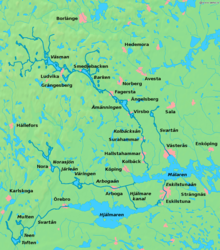
Map of Bergslagen
Bergslagen is a historically,[citation needed] culturally,[citation needed] and linguistically[1] distinct mining district located north of Lake Mälaren in northern Svealand, Sweden. In Bergslagen mining and metallurgic industry have been important since the Middle Ages. The region is to be distinguished from Malmfälten ("the Ore Fields"), the mining district of northernmost Sweden centered at the towns of Kiruna and Malmberget, that has been of greater importance during the 20th century.
Bergslagen covers part of the provinces of Västmanland, Dalarna (the southern part), and Värmland (the eastern part). Typical towns in the area include Nora, Fagersta, Sala, Kristinehamn, Filipstad, Ludvika and Hedemora. Also parts of northern Östergötland, around Finspång, as well as southern Närke can be included, then often referring to South Bergslagen. A wider definition of the area can include parts of Gästrikland (Hofors) and Uppland (the former iron manufacturing district centred on Dannemora) as well.
Contents
1 History
2 Minerals and mining
3 See also
4 References
5 External links
History[edit]
The conflict of interests between iron exports from Bergslagen and territorial conflicts at Denmark's southern border was a chief reason behind the Engelbrekt rebellion in 1434 and the following strifes that ultimately resulted in the dissolution of the Kalmar Union in 1523.
The region was an industrial powerhouse from the 17th century, up to the Steel crisis during the 1970s.
Minerals and mining[edit]

The Great Pit Stora stöten, Falun
The area is very rich in minerals. Mining has been focused on iron ore for centuries but other ores has been mined as well. Most mines are now closed, but in the 1970s many mines were still in operation. The earliest signs of iron making dates back to 400 BC while industrial scale activities dates back to the 17th century.
At Långban, where iron and manganese has been mined, 270 mineral species has been reported to date. Many of these minerals are unique to the Långban deposit, and 67 minerals were first found at this site.
See also[edit]
- Ecomuseum Bergslagen
- Falu red
- Roslagen
- Mälaren Valley
References[edit]
^ Josephson, Olle. "Håll koll på diftongerna i sommar!". www.svd.se Svenska Dagbladet (in Swedish). Schibsted. Retrieved 13 December 2014.Bergslagstal ("Bergslagen speech")
.mw-parser-output cite.citationfont-style:inherit.mw-parser-output .citation qquotes:"""""""'""'".mw-parser-output .citation .cs1-lock-free abackground:url("//upload.wikimedia.org/wikipedia/commons/thumb/6/65/Lock-green.svg/9px-Lock-green.svg.png")no-repeat;background-position:right .1em center.mw-parser-output .citation .cs1-lock-limited a,.mw-parser-output .citation .cs1-lock-registration abackground:url("//upload.wikimedia.org/wikipedia/commons/thumb/d/d6/Lock-gray-alt-2.svg/9px-Lock-gray-alt-2.svg.png")no-repeat;background-position:right .1em center.mw-parser-output .citation .cs1-lock-subscription abackground:url("//upload.wikimedia.org/wikipedia/commons/thumb/a/aa/Lock-red-alt-2.svg/9px-Lock-red-alt-2.svg.png")no-repeat;background-position:right .1em center.mw-parser-output .cs1-subscription,.mw-parser-output .cs1-registrationcolor:#555.mw-parser-output .cs1-subscription span,.mw-parser-output .cs1-registration spanborder-bottom:1px dotted;cursor:help.mw-parser-output .cs1-ws-icon abackground:url("//upload.wikimedia.org/wikipedia/commons/thumb/4/4c/Wikisource-logo.svg/12px-Wikisource-logo.svg.png")no-repeat;background-position:right .1em center.mw-parser-output code.cs1-codecolor:inherit;background:inherit;border:inherit;padding:inherit.mw-parser-output .cs1-hidden-errordisplay:none;font-size:100%.mw-parser-output .cs1-visible-errorfont-size:100%.mw-parser-output .cs1-maintdisplay:none;color:#33aa33;margin-left:0.3em.mw-parser-output .cs1-subscription,.mw-parser-output .cs1-registration,.mw-parser-output .cs1-formatfont-size:95%.mw-parser-output .cs1-kern-left,.mw-parser-output .cs1-kern-wl-leftpadding-left:0.2em.mw-parser-output .cs1-kern-right,.mw-parser-output .cs1-kern-wl-rightpadding-right:0.2em
External links[edit]
Ecomuseum Bergslagen - Official site- Långban and its minerals
Coordinates: 59°50′N 15°45′E / 59.833°N 15.750°E / 59.833; 15.750
This Swedish geography article is a stub. You can help Wikipedia by expanding it. |
Categories:
- Bergslagen
- Mining in Sweden
- Metallogenetic provinces
- Sweden geography stubs
(window.RLQ=window.RLQ||).push(function()mw.config.set("wgPageParseReport":"limitreport":"cputime":"0.204","walltime":"0.318","ppvisitednodes":"value":549,"limit":1000000,"ppgeneratednodes":"value":0,"limit":1500000,"postexpandincludesize":"value":17683,"limit":2097152,"templateargumentsize":"value":991,"limit":2097152,"expansiondepth":"value":11,"limit":40,"expensivefunctioncount":"value":2,"limit":500,"unstrip-depth":"value":1,"limit":20,"unstrip-size":"value":3022,"limit":5000000,"entityaccesscount":"value":1,"limit":400,"timingprofile":["100.00% 285.419 1 -total"," 33.92% 96.815 1 Template:Refimprove"," 32.22% 91.964 1 Template:Reflist"," 27.92% 79.697 1 Template:Cite_web"," 26.93% 76.863 1 Template:Ambox"," 12.34% 35.210 2 Template:Citation_needed"," 12.12% 34.596 1 Template:Find_sources_mainspace"," 10.96% 31.296 2 Template:Fix"," 10.85% 30.976 1 Template:Coord"," 5.97% 17.035 1 Template:Sweden-geo-stub"],"scribunto":"limitreport-timeusage":"value":"0.127","limit":"10.000","limitreport-memusage":"value":3547440,"limit":52428800,"cachereport":"origin":"mw1333","timestamp":"20190314000736","ttl":2592000,"transientcontent":false););"@context":"https://schema.org","@type":"Article","name":"Bergslagen","url":"https://en.wikipedia.org/wiki/Bergslagen","sameAs":"http://www.wikidata.org/entity/Q820245","mainEntity":"http://www.wikidata.org/entity/Q820245","author":"@type":"Organization","name":"Contributors to Wikimedia projects","publisher":"@type":"Organization","name":"Wikimedia Foundation, Inc.","logo":"@type":"ImageObject","url":"https://www.wikimedia.org/static/images/wmf-hor-googpub.png","datePublished":"2003-04-21T12:17:09Z","dateModified":"2018-12-24T13:33:13Z","image":"https://upload.wikimedia.org/wikipedia/commons/7/7f/LA2-Bergslagen-vatten.png","headline":"area"(window.RLQ=window.RLQ||).push(function()mw.config.set("wgBackendResponseTime":103,"wgHostname":"mw1333"););